Overview
- Residential Lots
- SR
- 23.9
- Total Acres
Description
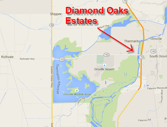
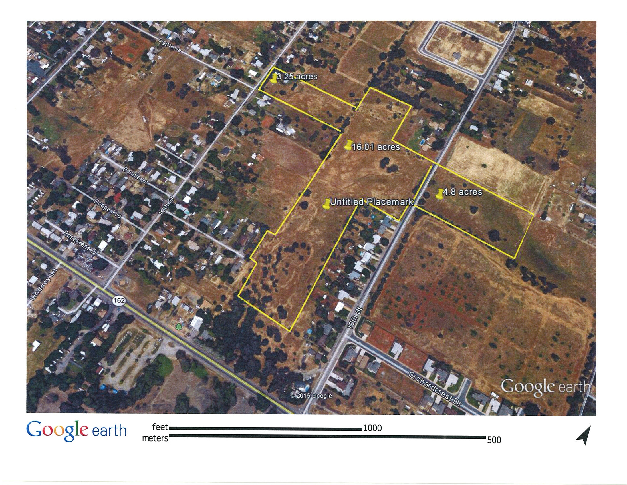
Diamond Oaks Estates Butte County Ca – The property consists of 3 individual parcels totaling 23.9 acres and has an approved tentative map for 95 single-family residential lots, a park site and areas for drainage detention. The parcel is situated in Thermalito, a quickly growing area just west of Highway 70, and just north of Oro Dam Blvd., (State Route 162). The 24 acre site is in a rural residential neighborhood. It is surrounded by low density residential neighborhoods, both established and new. The site is located within the City of Oroville’s Sphere of Influence and Urban Area designation.
LOCATION: Oroville, Butte County, California
APN’S: 030-132-005, 030-560-020 and 030-160-005
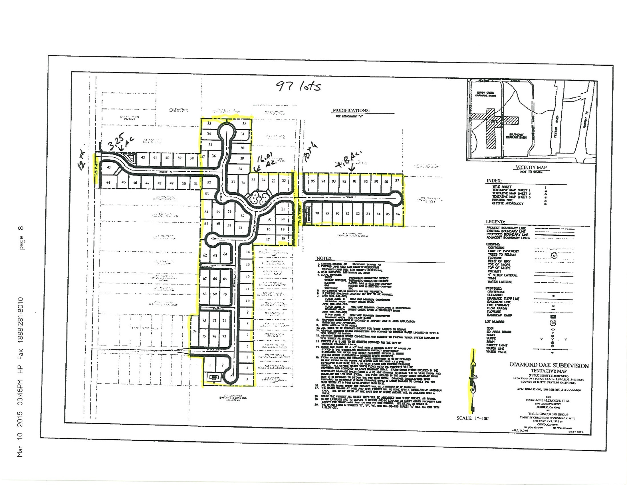
TENTATIVE MAP: 95 single-family residential lots.
APPROVALS: Butte County Environmental Health Department, Butte County Public Works Department, Butte County Planning Division, Butte County Fire Department, Butte County Agricultural Commissioner, Butte County Air Quality Management District, City of Oroville, Oroville Union High School District, Thermalito Union School District, Caltrans, California Department of Fish and Game, Regional Water Quality Control Board, U.S. Army Corps of Engineers, and the U.S. Fish and Wildlife Services.
DEVELOPMENT ENTITLEMENTS: Single Family Residential Tentative Map calendared for July 2007 Planning Commission Hearing and approvals. The Development Services Department of Butte County is currently finalizing the Initial Study and Proposed Mitigated Negative Declaration for the Tentative Sub-Division Map and Conditions of Approval.
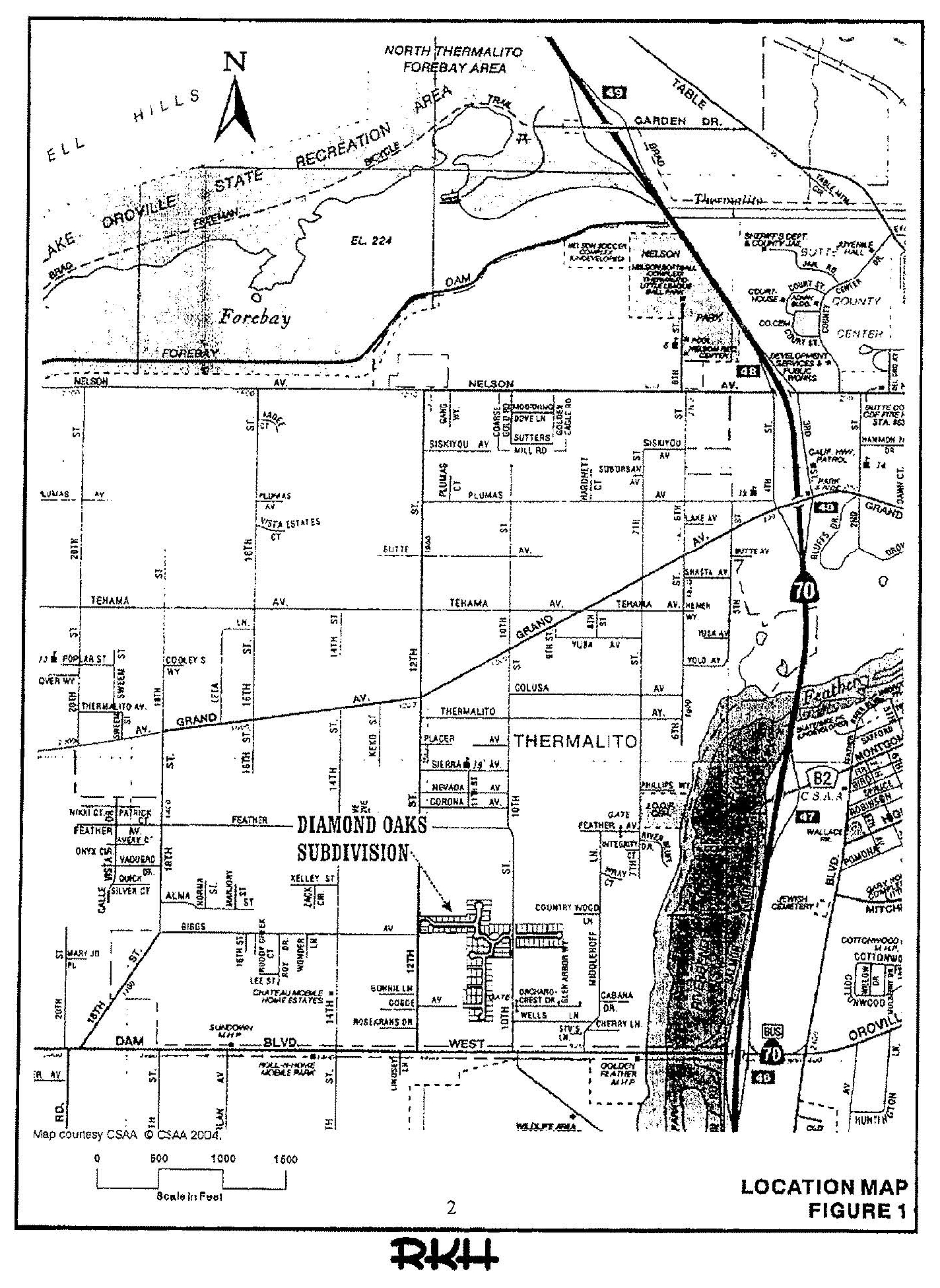
PROPERTY LOCATION: The subject property is located north of Oro Dam Blvd. (State Route 162) and south of Grand Avenue in Thermalito, California, approximately ½ mile west of the City of Oroville, CA. Assessor parcel number 030-132-005 and 003-560-020 are located between 10th and 12th streets and assessor parcel number 030-160- 005 is east of 10th Street. The neighborhood’s boundaries are State Highway 70 and the Feather River to the east, State Route 162 to the South and Grand Avenue to the North. The site is located just minutes from Oroville’s major commercial and shopping area. The site is easily accessible by both freeway and surface streets.
BUTTE COUNTY TENTATIVE SUBDIVISION MAP: 05-14.
PROJECT DESCRIPTION: The project will subdivide three (3) parcels totaling 24 acres to create 95 single- family residential lots and related infrastructure such as roads, sanitary sewer, domestic water and drainage facilities. Two major access points to the subdivision are utilized. The first is at 12th street and the second at 10th street.
TOPOGRAPHY & DRAINAGE: The topography gently slopes toward the center of the site, then drains south and west into established and approved drainage channels. A high point occurs in the northern portion of APN 030-560-020. The elevation of the high point is approximately 182 feet above sea level. Two drainage ditches (ditch 1 and 2) occur at the low points of the property. The site gently slopes from east to west and in the Ruddy Creek Basin of the Thermalito Master Drainage Plan.
PUBLIC AGENCY APPROVALS: Butte County Environmental Health Department, Butte County Public Works Department, Butte County Planning Division, Butte County Fire Department, Butte County Agricultural Commissioner, and Butte County Air Quality.
STREET NAMES: The following street names have been reserved for this project:
Diamond Oaks Drive (includes both sides of 10th street)
Sapphire Oaks Drive
Amethyst Court
Citrine Court
Lapis Court
Camelian Court
LOT SIZE AND UTILITY: When completed, the lots will have a good utility function as residential home sites. Lot sizes range in size from 6,500 sq. ft. to 10,472 sq. ft. The lots will support both single and two-story construction, and will support homes with three-garages.
FLOOD ZONE: The project is within Flood Zone “X” according to the Federal Emergency Management Agency (FEMA) flood insurance rate maps. This zone indicates the property is in an area not inundated by either 100 or 500 year flooding.
SEISMIC ISSUES: The property is not located in an identified earthquake hazard area based on the Alquist-Priolo special studies.
INFRASTRUCTURE:
Water provided by Thermalito Irrigation District (TID).
Sewer provided by Thermalito Irrigation District (TID).
Drainage: On-site detention basins (3 each) hold water prior to discharge to off-site discharge.
PRICE: $679,000. The purchase price equates to $7,147 per paper lot or $18,221 per acre. Priced to sell!!
Details
Updated on July 21, 2015 at 12:00 am- Property ID / MLS #: SR
- Price: $679,000
- Property Type: Residential Lots
- Property Status: Available
- Total Acres: 23.9
Address
- City Oroville
- State California
- Zip/Postal Code 95965
- Country United States


